| Textbook | NCERT |
| Board | CBSE Board, UP board, JAC board, HBSE Board, Bihar Board, PSEB board, RBSE Board, UBSE Board |
| Class | 6th Class |
| Subject | GEOGRAPHY | Social Science |
| Chapter | Chapter 4 |
| Chapter Name | Maps |
| Topic | Maps CBSE Class 6 GEOGRAPHY Chapter 4 Notes |
| Medium | English |
| Especially Designed Notes for | CBSE, ICSE, IAS, NET, NRA, UPSC, SSC, NDA, All Govt. Exam |
Maps
A map is a representation or a drawing of the earth’s surface or a part of its area drawn on a flat surface according to a scale.
Types of Maps
Maps provide more information than a globe. They are of different types.
Some of them are as follows:
- Physical Maps Maps showing natural features of the earth such as mountains, plateaus, plains, rivers, oceans etc are called physical or relief maps.
- Political Maps Maps showing cities, towns, villages and different countries and states of the world with their boundaries are called political maps.
- Thematic Maps Maps with specific information like road maps, rainfall maps, maps showing distribution of forests, industries etc are known as thematic maps.
Components of Maps
There are three components of maps (i) distance (ii) direction (iii) symbol
(i) Distance
- Maps are drawings, which reduce the entire world or a part of it on a sheet of paper.
- Maps are drawn to reduced scales.
- This reduction is done very carefully so that the distance between the places is real.
- It can only be possible when a small distance on paper represents a large distance on the ground through a scale.
Scale
- Scale is the ratio between the actual distance on the ground and the distance shown on the map.
- A small scale map is used to show large areas like countries or continents on a paper. For example, 5 cm on the map shows 500 km of the ground.
- A large scale map is used to show a small areas like village or town on a paper. For example, 5 cm on the map shows 500 metre on the ground.
(ii) Direction
- Most maps contain an arrow marked with the letter ‘N’ at the upper right hand corner.
- This shows the North direction. It is called the North line”.
- There are four major directions- North, South, East and West.
- They are called cardinal points.
- North-East (NE), South-East (SE), South-West (SW) and North-West (NW) are other four directions which are called intermediate directions.
Compass
- Direction of a place can be found out with the help of an instrument called compass.
- Its magnetic needle always points towards the North-South direction.
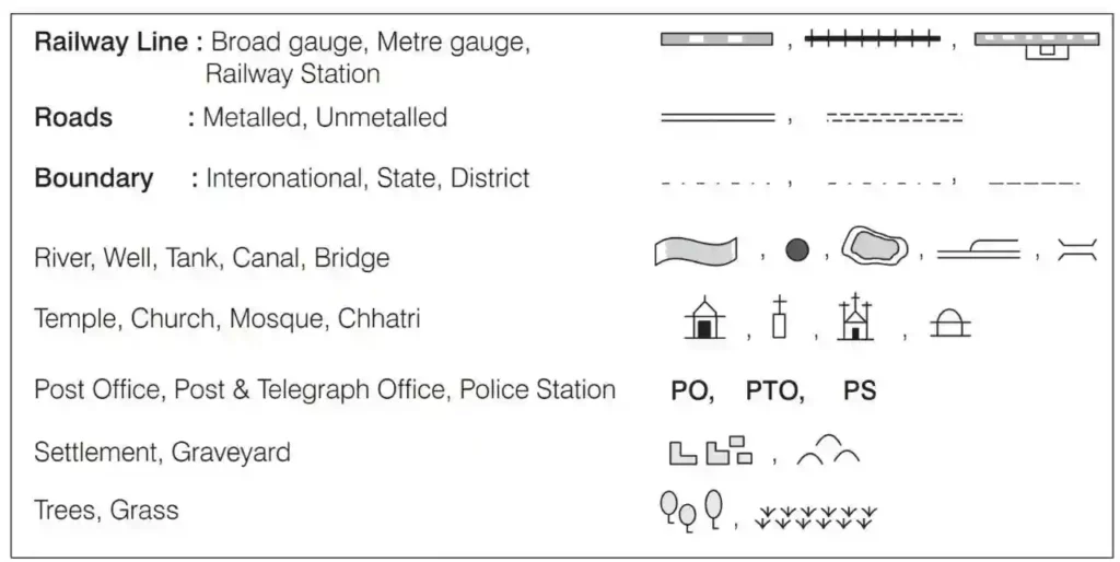
(iii) Symbols
- Symbol is the third important component of a map.
- It is impossible to draw exact size of different features such as buildings, roads, bridges, trees, railway lines or a well on a map.
- So they are shown by using certain letters, shades, colours, pictures and lines.
- These symbols are drawn easily and give many informations in a limited space.
- The maps have a universal language so that it can be understood by the people speaking any language.
- There is an international agreement regarding the use of these symbols and these are called conventional symbols.
Sketch
- A sketch is a drawing mainly based on memory and spot observation and not to scale.
- Sometimes, a rough sketch is required of an area to tell, where a particular area is located with respect to other places.
- Suppose you want to go to your friend’s house and you don’t know the way, then your friend may make a rough sketch to show the way to his house.
- Such a rough drawing is called a sketch map.
Plan
- Plan of an area consists of details about length and breadth of a particular location.
- A plan is a drawing of a small area on a large scale or in other words, a drawing drawn to scale is called a plan
One word meaning
- North line An arrow marked with the letter ‘N’ at the upper right hand corner of a map is called the North line
- Compass An instrument which indicates the direction is called compass
- Conventional symbols Symbols that are used internationally under an international agreement are called conventional symbols