| Textbook | NCERT |
| Board | CBSE Board, UP board, JAC board, HBSE Board, Bihar Board, PSEB board, RBSE Board, UBSE Board |
| Class | 6th Class |
| Subject | GEOGRAPHY | Social Science |
| Chapter | Chapter 7 |
| Chapter Name | Our Country India |
| Topic | Our Country India CBSE Class 6 GEOGRAPHY Chapter 7 Notes |
| Medium | English |
| Especially Designed Notes for | CBSE, ICSE, IAS, NET, NRA, UPSC, SSC, NDA, All Govt. Exam |
Our Country India
- India is a country of vast geographical expanse.
- In the North, it is bound by the lofty Himalayas.
- The Arabian Sea in the West, the Bay of Bengal in the East and the Indian Ocean in the South, wash the shores of the Indian peninsula.
- India has an area of about 3.28 million sq. km.
- The North-South extent from Kashmir to Kanyakumari is about 3,200 km and the east-west extent from Arunachal Pradesh to Kuchchh is about 2,900 km.
- The lofty mountains, the Great Indian Desert, the Northern Plains, the uneven plateau surface and the coasts and islands present a diversity of landforms.
- It has a great diversity in the climate, vegetation, wildlife as well as in the language and culture but also has unity which is reflected in traditions that bind us as one nation.
Locational Setting
- India is located in the northern hemisphere.
- The Tropic of Cancer (23°30’N) passes almost halfway through the country.
- From South to North, India extends between 8°4’N and 37°6’N latitudes.
- From West to East, India extends between 68°7’E and 97°25’E longitudes.
- Due to great longitudinal extent of about 29°, there could be wide differences in local time of places located at two extreme points of India.
- The local time changes by four minutes for every one degree of longitude.
- That’s why there is difference between these two points by about two hours.
- The sun rises two hours earlier in the east (Arunachal Pradesh) than in the west (Gujarat).
- In order to solve this time difference as well as to get accurate time the local time of longitude of 82°30’E has been taken as the Indian Standard Time.
- This meridian or longitude is also termed as the ‘Standard Meridian’ of India.
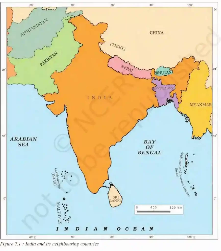
India’s Neighbours
- India shares its land boundary with seven countries, such as with China, Bhutan and Nepal to the North, Pakistan and Afghanistan to the West and Bangladesh and Myanmar to the East.
- Sri Lanka and Maldives are its island neighbours which lie across the sea to the South. The Palk strait separates Sri Lanka from India.
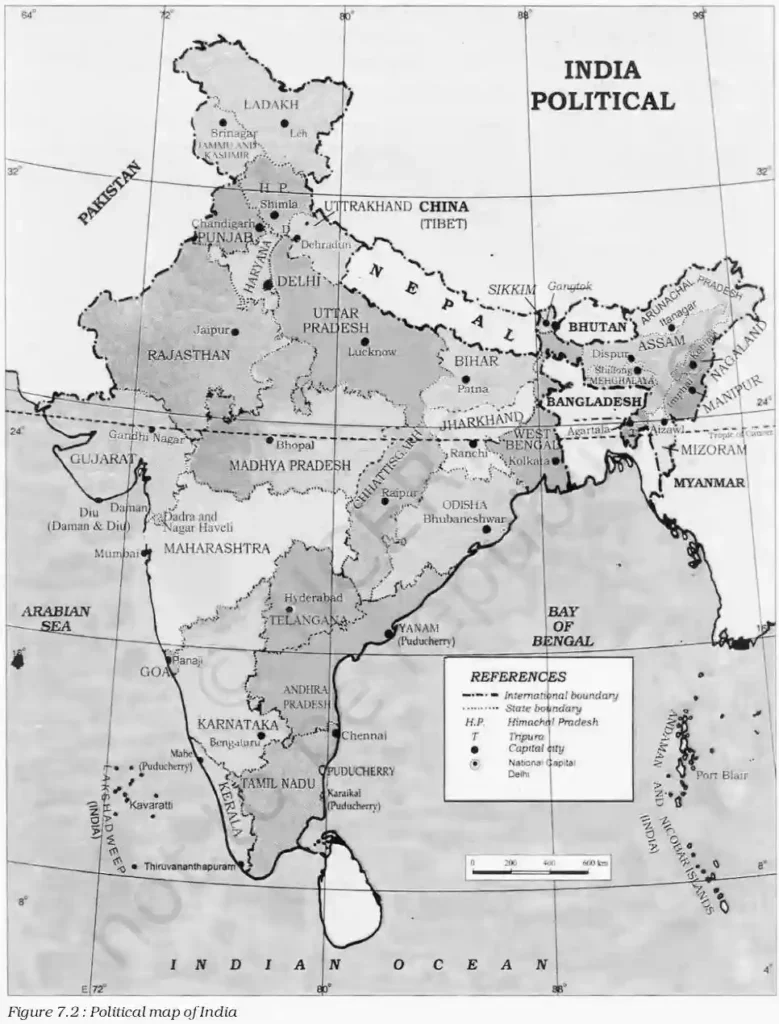
Political and Administrative Divisions
- India is a vast country which is divided for administrative purposes into 29 States and 7 Union Territories.
- The states are further divided into districts.
- Delhi is the national capital.
- The basis for the formation of the states are languages.
- As far as the area is concerned the largest state is Rajasthan and the smallest state is Goa.
Physical Divisions
- India has a variety of physical features such as mountains, plateaus, plains, coasts and islands.
- Standing as sentinels in the north are the lofty snowcapped Himalayas.
Himalayan Mountain
- Himalaya means ‘the abode of snow’.
- The Himalayan Mountains are divided into three main parallel ranges.
- The Northernmost is the Great Himalaya or Himadri.
- The world’s highest peaks are located in this range.
- Middle Himalaya or Himachal lies to the South of Himadri, having many popular hill stations.
- The Shivalik is the Southernmost range.
Northern Indian Plains
- These lie to the South of the Himalayas and are generally level and flat.
- They are formed by the alluvial deposits laid down by the rivers- the Indus, the Ganga, the Brahmaputra and their tributaries.
- These river plains are suitable for cultivation because of their fertility.
- So, become a home for large chunks of population.
Great Indian Desert
- The Great Indian Desert is found in the Western part of India.
- It consists of a dry, hot and sandy tract of land with no or very little vegetation.
Peninsular Plateau
- It is situated to the South of the Northern plains.
- It is triangular in shape and its relief feature is highly uneven.
- Hence, it has numerous hill ranges and valleys.
- It is rich in minerals like coal and iron-ore.
- Aravalli hills, one of the oldest ranges of the world, border it on the North-West side.
- The Vindhyas and the Satpuras are the important ranges.
- The rivers Narmada and Tapi flow through these ranges.
- These are West flowing rivers that drain into the Arabian Sea.
- The Western Ghats or Sahyadris border the plateau in the West and the Eastern Chats provide the Eastern boundary.
- While the Western Ghats are almost continuous, the Eastern Ghats are broken and uneven.
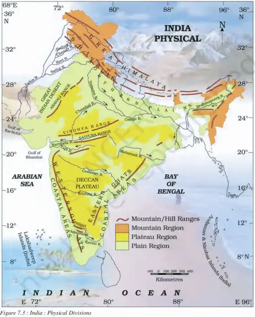
Coastal Plains and Islands
- Both Western Ghats and Eastern Ghats having the coastal plains.
- The Western coastal plains are very narrow.
- whereas Eastern coastal plains are much broader.
- There are a number of East flowing rivers. The rivers Mahanadi, Godavari, Krishna and Kaveri drain into the Bay of Bengal.
- These rivers have formed fertile deltas at their mouth.
- The Sunderban delta is formed where the rivers Ganga and Brahmaputra flow into the Bay of Bengal.
Groups of Islands
- Lakshadweep and the Andaman and Nicobar Islands are two groups of island found in India.
- Lakshadweep Islands are located in the Arabian Sea.
- These are coral islands located off the coast of Kerala.
- The Andaman and Nicobar Islands lie to the South-East of the Indian mainland in the Bay of Bengal.
- These Islands were affected by the Tsunami in 2004.
- Tsunami is a huge sea wave generated due to an earthquake on the sea floor.
Fact
The Ganga and the Brahmaputra form the world’s largest delta, the Sunderbans delta. The delta is triangular in shape. It is an area of land formed at the mouth of the river (Where rivers enter into the sea, that point is called the mouth of the river
- Strait A narrow channel of the sea joining two larger bodies of water.
- Alluvial deposits These are very fine soils, brought by rivers and deposited in the river basins.
- Delta A low triangular area of alluvial deposits where a river divides before entering a larger body of water.