| Textbook | NCERT |
| Board | CBSE Board, UP board, JAC board, HBSE Board, Bihar Board, PSEB board, RBSE Board, UBSE Board |
| Class | 6th Class |
| Subject | GEOGRAPHY | Social Science |
| Chapter | Chapter 2 |
| Chapter Name | Globe Latitudes and Longitudes |
| Topic | Globe Latitudes and Longitudes CBSE Class 6 GEOGRAPHY Chapter 2 Notes |
| Medium | English |
| Especially Designed Notes for | CBSE, ICSE, IAS, NET, NRA, UPSC, SSC, NDA, All Govt. Exam |
Globe : Latitudes and Longitudes
- Our planet earth is not completely a sphere but slightly flattened at both poles (North and South) and bulge in the middle.
- Globe is a true model of the Earth (in a small form).
- The size of the globe varies from small to big.
- The countries, continents, and oceans are shown in their respective sizes on the globe.
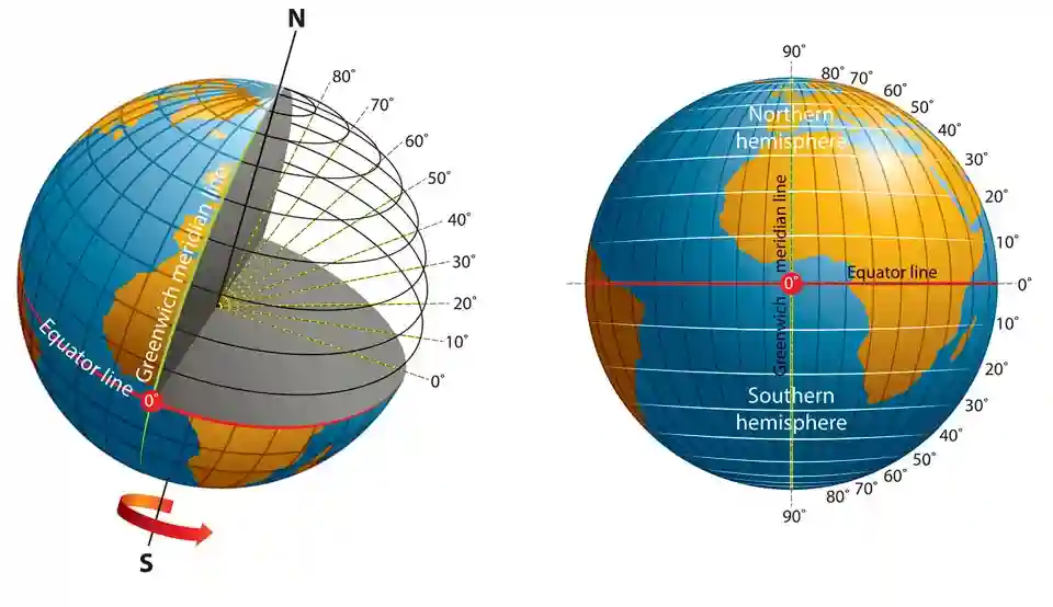
Axis
- The needle fixed through the globe in tilted manner is called its axis, but the real Earth does not possess axis.
- The Earth moves around its axis, which is an imaginary line.
- The two points on the globe where the needle passes through are North Pole and South Pole.
- The globe can be moved around this needle like the Earth from West to East.
Equator
It is another imaginary circular line which runs through the globe and divides the Earth into two equal parts.
- Northern hemisphere The Northern half of the Earth is known as Northern hemisphere.
- Southern hemisphere The Southern half of the Earth is known as the Southern hemisphere.
Therefore the equator is a very important reference point to locate places on the Earth.
Latitudes
- An imaginary circle parallel to the equator is called latitude.
- All parallel circles from the equator up to the poles are called parallels of latitudes.
- These are measured in degrees.
- All parallel circles in North of the equator are called North latitudes while all parallels South of the equator are called South latitudes.
- The equator represents the zero degree latitude. The distance from the equator to either of the poles is one-fourth of a circle round the Earth (1/4th of 360 degrees, i.e. 90°).
- Hence, 90 degrees North latitude marks the North Pole and 90 degrees South latitude marks the South Pole.
- The North and South latitude indicated by letter ‘N’ and ‘S’ respectively.
- As we move away from the equator, the size of the parallels of latitude decreases.
Difference between North and South Latitude
- Chandrapur in Maharashtra (India) and Belo Horizonte in Brazil (South America) are located on parallels of about 20° latitude.
- But the difference between both locations is their position in North and South latitudes respectively.
- Chandrapur in India is situated at 20° North of the equator while Belo in Brazil at 20° South of the equator.
- Therefore, we indicate that Chandrapur is at 20° N latitude and Belo Horizonte at 20° S latitude.
Important Parallels of Latitudes
Apart from the equator (0°), the North Pole (90° N), and the South Pole (90° S), there are four other important parallels of latitudes. They are:
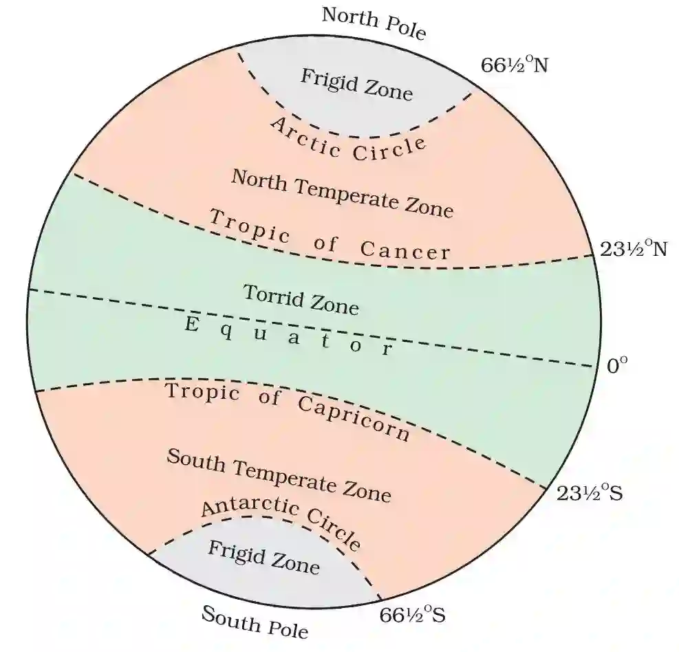
- Tropic of Cancer It is an imaginary line that crosses at 23 1/2 N in the Northern hemisphere.
- Tropic of Capricorn It is an imaginary line that crosses at 23 1/2 S in the Southern hemisphere.
- Arctic Circle It is a circle at 66 1/2 North of the equator.
- Antarctic Circle It is a circle at 66 1/2 South of the equator.
Heat Zones of the Earth
Heat zones of the earth are as follows:
Torrid Zone
- The mid-day sun atleast once in a year is exactly overhead on all latitudes in area between the tropic of Cancer and tropic of Capricorn.
- Therefore, the area between the tropic of Cancer and tropic of Capricorn receives the maximum heat and the region is called Torrid zone.
- The area (latitude) beyond Torrid zone does not receive heat of overhead sun.
- The angle of the ray of sun goes on decreasing towards the poles.
Temperate Zones
- The areas between the Arctic circle and tropic of Cancer in Northern hemisphere and the Antarctic circle and tropic of Capricorn in the Southern hemisphere is the region of moderate temperatures.
- These regions are called Temperate zones
Frigid Zones
- The areas lying between the Arctic circle and the North pole in the Northern hemisphere and the circle of Antarctic and the South pole in the Southern hemisphere remains very cold because the sun provides less heat due to its slanting rays.
- These regions are called Frigid zones” (Very cold).
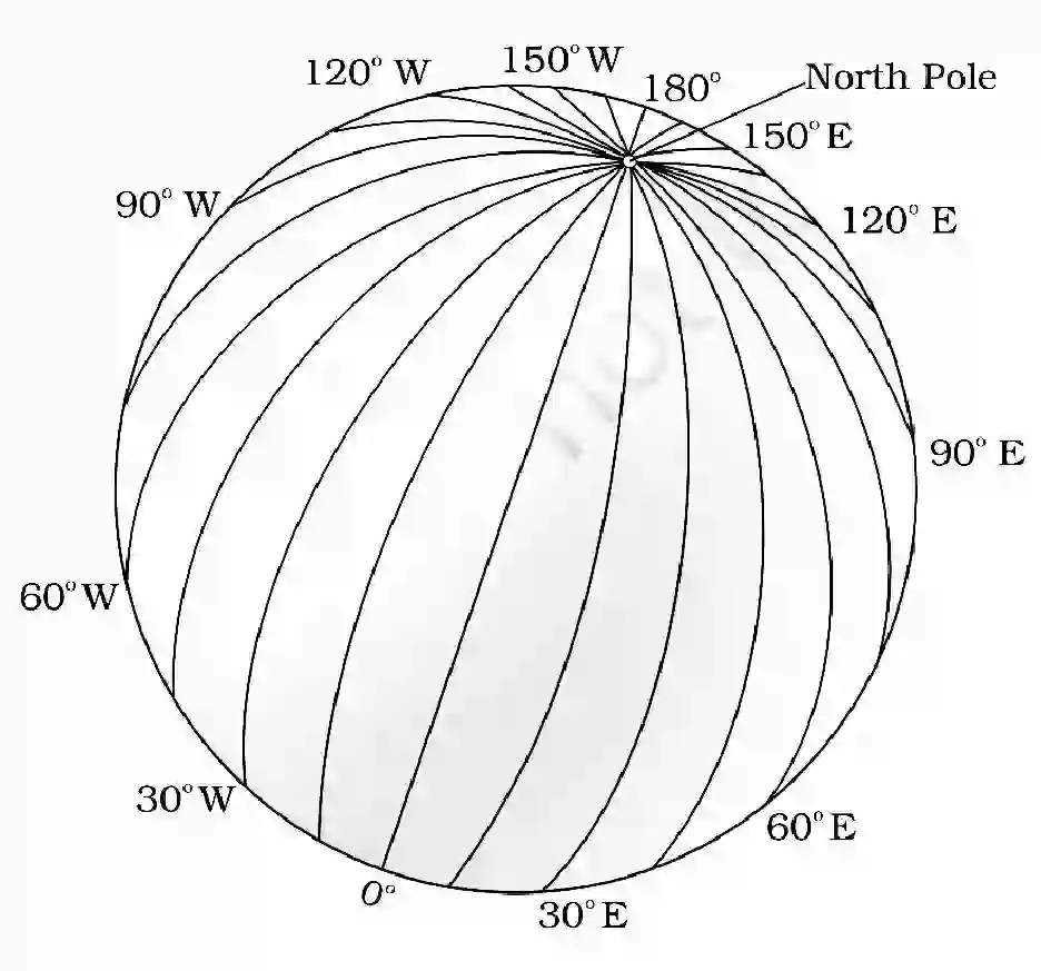
Longitudes
- One of the imaginary circles parallel to the Prime Meridian is called longitudes.
- To fix the position of a place on the Earth, it is necessary to know how far East or West the place is from the given point of reference (latitude).
For example Tonga Islands in the Pacific ocean and Mauritius Islands in the Indian ocean are situated on the same latitude (20° South).
These East or West lines of references are called meridians of longitude. On the basis of longitudinal and latitudinal position of any place, we can locate it.
- The distances between meridians of longitude are measured in degrees of longitude.
- Each degree is further divided into minutes and minutes into seconds.
- These are semi-circles and the distance between them decreases while moving polewards and becomes zero at poles (The point where all the meridians meet).
- It is noteworthy that all meridians are of equal length unlike parallels of latitude. So, it was difficult to number the meridians.
- Hence, all countries decided that the count of longitude should begin from the meridian which passed through British Royal Observatory at Greenwich in England.
- Thus, it is called Prime Meridian. The value of this meridian is 0° longitude and from it, 180° Eastward and 180° Westward is counted.
- The Earth is divided into two equal halves: one is the Eastern hemisphere and other is Western hemisphere.
- The letter ‘E’ is represented for the East and ‘W’ is for West. The 180° East and 180° West meridians are on the same line.
Longitude and Time
- The movement of the Earth, the moon and the planets are the best means to measure time.
- The local time is reckoned by the sunset and sunrise when the shadow cast by the sun is shortest at noon and longest at sunrise and sunset.
- When the Prime Meridian at Greenwich has the sun at the highest point, all the places along this meridian will have mid-day or noon.
- The places, which are East to Greenwich will be ahead of Greenwich time while the places to its West will be behind it because the Earth rotates from West to East
Standard Time
- The local times of places on different meridians are different.
- Therefore, it will be difficult to prepare timetables for trains which cross several longitudes.
- For example, there will be a difference of about 1 hour and 45 minutes in the local times of Dwarka in Gujarat and Dibrugarh in Assam.
- Therefore, it is necessary to adopt the local time of some central meridian of a country as the standard time for the country.
- In India, 82% East (82° 30′ E) is treated as the standard meridian and taken as the standard time for the entire country. It is known as the Indian Standard Time (IST).
- India is located at 82° 30′ East of Greenwich means 5 hours 30 minutes ahead of Greenwich meantime. If it is 7.30 p.m. in India, it will be 2 p.m. noon in London.
- In some countries which have a great geographical extent, they adopted more than one standard time.
- In Russia, there are eleven standard times.
- The Earth has been divided into twenty-four time zones of one hour each, each covers 15° of longitude.
One word meaning
- Globe: it is a true model of the Earth.
- Axis: The Earth moves around its axis.
- Equator: The line that divides the Earth into two equal halves is called equator
- Latitudes: All parallel circles from the equator upto poies are called latitudes.
- Tropic of Cancer: An imaginary line that crosses at 82% in Northern hemisphere.
- Tropic of Capricorn: An imaginary line that crosses at 82s in Southern hemisphere
- Arctic Circle: A circle at 66 % North of the equator.
- Antarctic Circle: A circle at 66 y South of the equator.
- Torrid Zone: The area that receives maximum heat is called Torid zone
- Temperate Zone: The regions of moderate temperature are called Temperate zone.
- Frigid Zone: The region with extremely low temperature is called Frigid zone.
- Longitudes: All parallel lines running from North Pole to South Pole are called longitudes.
- Prime Meridian: The standard line, which is accepted by all nations and considered as international standard time.